Thursday, November 28, 2013

Cayos Cochinos and the Quartet of Dive Masters

It all started when we rescued Anthony and a friend from a poorly planned canoe outing. They were being blown out of the bay and were attempting to paddle back with a board, as they had no paddles. We watched them for awhile commenting on their sorry state of affairs and when Anthony jumped in the water and tried to pull the canoe along we finally gave in and went over with the dinghy to rescue them. Upon returning to shore Anthony offered to buy us a beer. We then met his wife Alma and friend Laura. There were lots of questions on how we liked the boating life and if they (Anthony & Alma) were to buy a boat what should they get. We offered to take them sailing as they hadn't sailed before. Laura however had been on boats. We were not sure they would take us up on the offer as they were very busy with the finals of dive master classes which they would be finishing up in the next few days.

One afternoon several days later, here they come swimming out to Leap from the dive shop in swim rings. The guys Anthony and Danny were in swim rings too and bringing the beer. They offered to bring back fresh tuna that they had purchased from a local fisherman and we would make ceviche and talk sailing plans.
And so began our friendship and a sailing trip to Cayos Cochinos.


Alma Baer and Laura Adams

                                              Anthony and Alma Baer and Laura Adams
Alma

Anthony

Laura


Danny and Alma
All four are backpackers and have been traveling extensively in Central America and are headed south.
Danny is from Spain and is heading for Nicaragua; we will drop him off in La Ceiba, a port on the mainland, on our return sail to Utila.
Laura is from Prince Rupert BC Canada and is headed to Costa Rica then on to Hawaii. Anthony and Alma are from Sacramento, CA  and also heading for Nicaragua. The three will be taking the ferry out of Utila to La Ceiba on Tuesday 11/26 heading to San Pedro Sula catching buses and trekking on.


Dolphins at play from Utila to Cayos Cochinos

Cayos Cochinos are a group of islands located 29 miles southeast of Utila. The island group was declared a Marine National Monument in 2003 and has its own research station, which we've read, welcomes volunteers. We arrived at night - AGAIN - making the count 5 of 8. In the morning we woke to a beautiful double rainbow. 


We moved to this small cove for a morning of snorkeling.

Charlie on the foredeck

The above picture of Leap and the following underwater pictures were taken by the dive masters.
Purple Sea Fans

Brain Coral with Christmas Tree Worms

Laura found a treasure
A young Hawksbill 


Laura and Alma


Charlie cleaning the fish we bought from a local Garifuna fisherman that paddled up to Leap in his cayuga.


We learned all kinds of things from this group but one of the funniest items was from Laura who did/does a lot of camping. We were talking survival skills and what one needs to know in differing circumstances. Laura says she never goes camping without cheetos as they are the best fire starters. None of us of course believed her and she persisted in trying to convince us it was true. Charlie had to see for himself. 
Yes indeed, the little cheetos do put out quite a flame and yes you can start a fire with them.


I
Setting sail for Utila after dropping Danny in La Ceiba

Alma and Anthony Baer


Laura Adams, Karen, Alma, Charlie


Karen 


Sunset in route to Utila and yes, we arrived in the dark. 6 of 9!

Wednesday, November 27, 2013

Utila Scenes

Leap at anchor in East Harbor 


Our view of the mountains on the mainland of Honduras is shrouded in clouds most of the time.


Going to town for dinner at the Jade Seahorse


 This picture of just a small portion of the Jade Seahorse does not do the place justice. The owner as been working on the sculptures and ornamentation for 15 years and still going. He is having website issues now but should the site come back up you should visit it.


The sign below for bike (scooter) rentals advises the maximum speed of 25 km/hr, however, no one goes that slow. The main drag is a very narrow street and no sidewalks. Consequently between the scooters, ATV's,  golf carts and 3-wheel taxis the pedestrian is always on the lookout and forever hopping out of the way.


This is one of the most photographed signs in Utila. The casket shop shares the building with the above bike rental shop.


Street is quiet right now. 


                                                                  Three wheel taxis


                                   Golf Cart and ATV's  also. As you can see there is no parking so                                                                  vehicles get left here and there, and other drivers jostle on by.
             
During the busy times of day the street is jammed with vehicles and it is a transportation free for all.  It's a -  pedestrians beware - driving attitude.  There is not a sidewalk

The only vehicle not showing in the pictures is the three wheel bikes. One wheel in back two wheels in front with large platform baskets on the front. The other day a gentleman had a refrigerator in his basket and he could not see but pressed on waving his fist over the top, calling out his intentions, turning left through the major 4-way intersection and everyone came to a halt with a screeching of brakes and expletives.
We theorized his need to push on through was due to having momentum, as we imagined it a bit of a struggle to get the whole shebang rolling.


Sunset  - the rays were quite spectacular this evening.
The next two pictures were taken by our dive master friends, Anthony and Alma Baers and Laura Neadam. Leap is the second sailboat from the right out in the distance.


Wednesday, November 20, 2013

Belize to Utila, Honduras

San Pedro, Belize to Utila Honduras

Wednesday  11/6

Even though staying in Belize was not an option  for us, the coming nights’ sailing conditions were promising.  It seemed we should have no problem arriving in Utila during daylight hours the following day. So off we went, clearing San Pedros’ reef at 1600, in beautiful weather, great wind  and nearly smooth seas at 1ft.  Postcard sailing weather with winds on the beam out of the NE at 10 to 15 knots giving us a speed of 6 knots plus. We were so shook up after the incident with the Port Captain, but so happy to have great sailing weather, we had a token rum punch - as we like to keep our wits about us while sailing, imbibing too much is not an option. We set a course that would take us east over the north end of  Belizes’ Turneffe Islands and  further east on past the north end of  Lighthouse Reef.  All was going well and we settled into our routine of  rotating watches. Auto had the helm.

On our previous overnight sail, from Bahia to Belize we had some rainy weather and got wet, and consequently, cold. Yes, we have full foul weather gear but did not wear our bibs, so we got wet. We know you’re thinking, “Heck, they’re in the tropics and it shouldn’t be cold.”  But wet, at night, makes for cold.  So, to be on the safe and dry side we had at the ready, our cockpit enclosure, so that should it rain, we could drop the curtains and zip up and stay dry.  And yes, we had our bibs close at hand this time. Note to remember for later: we have a full enclosure but only readied the front and sides.

At 0100 on Thursday 11/7 we made a course change  - as in - hung a right and headed down towards Utila and sailed right out of wind. At night it is sometimes hard to read cloud formations or see storms but something was sucking up all the wind.  We tried motor sailing for awhile but the sails were flogging violently and we could not manage to calm them down. The waves were coming from multiple directions, which exacerbated the problem, so down came the sails and we motored on until dawn.  

At 0645 we were able to raise the sails and  make some headway toward Roatan with the plan of jibing back and forth to avoid a down wind course to Utila. Winds were mostly dead astern. The storm oscillated between annoying and a full blown gale. We passed from - doldrums, sails down, motor on, to - moderate wind , sails up, motor off, to - roiling seas, high winds, sails down, motor on, and then a few nautical miles further it started all over again. This storm totally surrounded us and unbeknownst to us, would be a serious threat for the next 24 hours.

We kept commenting on the various storm clouds; “What the heck?”  - “Is that one going to hit us?” - “What’s with these storms all around us?”  - “What’s going on now!?” - “ That one missed us.” - “ Could stand for a freshwater rinse, ya’ think the next one will hit us?”   and so on.

But the real clincher to the all the foul weather downwind sailing was……..the wind and rain blew in over the stern!

Soooooo, we said on several occasions, back and forth to each other, “Ya’ know we have a full enclosure but, did we get it out from storage under the V-berth? Noooooooo…. Are we going to go up there now and stand on our heads and try to wrench the rest of the parts out of there while Leap is bucking and rolling  around like a puppy rolling in dead fish? Noooooo!   Damn good thing we had our bibs on.

We had 65 miles to go but were barely making 4 knots and we had 12 hours of daylight  and we were going to be stuck  ----- UGH ---- entering another harbor at night  -   and we really don’t like that.  Since crossing the Gulf we have managed to have 3 of the last 6 harbor entries at night, and it looked like we were going for 4 out of  7.

The thing about anchoring in harbors you don’t know, is that you can’t  necessarily believe what the cruising guides or charts say. Not necessarily because they are wrong, but because things may have changed since the guide or  chart was published ( or the GPS places us in the middle of the island instead of the middle of the bay).  Things like: the lighthouse is old and no longer operable, or the white building with the red roof is no longer that color, or perhaps no longer stands. Or, enter between the breaking reefs - which are gone now due to hurricanes or did they just die?  And then there is this little nugget; There may be a white stick ya know, and ya turn by that, but not so far as to run into the coral head which is supposed to have a white stick too.

Now during the day one can see  most things that you do not want to hit, but night has a way of distorting everything from depth perception to analyzing lights. Locating the flashing lights you need to stay away from is difficult, especially when the lights are backed by a town full of lights that have nothing to do with the light you are searching for. Or, trying to search out the red and green buoy lights  you are supposed to follow - if they even have them -  except the islands roadway is right on the beach and they have stop lights.  That bit of green flash here, then red flash there, is just a bit confusing for a few brief minutes until your brain kicks in and starts sorting out the sensory overload. And who knows what color any of the buildings are, and those white sticks?  - of course they’re not lit!

We have  computer navigation  with GPS so we can see on screen where the GPS thinks Leap is and we are very fortunate to have this system, especially at night in unknown harbors. This night in Utilas’ harbor will build a strong case for GPS navigation.

It is now 1930 and we are sailing down the eastern shore of  Utila and can see the lights of Roatan off to our port.  The winds have moderated but the seas have not settled.  In the distance ahead we can see lights on the water, fishing boats.  Hard to believe they are out in this weather.  We do not want to sail through them, not knowing if they are hook and line fishing or net fishing,  so we will circle around outside of them then head west along the southern shore in search of the harbor entrance.

The Mesoamerica barrier reef runs along the Bay Islands and we proceed with caution to make sure we  clear the reefs’end that juts out into the harbor entrance.  The flashing light marking the reef is nearly impossible to see against the back drop of the town.  We use our computer GPS tracking  to steer around the reefs’ end, dodging the charted coral heads, heading for the anchorage.  We start the process of lining ourselves up with the red cell tower lights and the church steeple, just like the book says …….except…. there are two church steeples.  But by now we can make out enough of the harbor and see the other sailboats, so we set anchor, it is now 2105. The anchorage is calm as it is protected by the island from all points except southwest.  But that’s ok -  because the storm is out on the northeast side. So we settle in for some much needed sleep.

Well …….. that didn’t last long.

0230  on 11/8 we were awakened and at 0300  ……

 The storm that had been dogging us for the last 20 hours just kept on a comin’.   The winds clocked around to the southwest at near gale force, the rain pounded down in a blinding torrent, the lightning was fierce, the anchorage churned and spewed, tossing  us and the other boats every which way. We were right in the gullet as the storm marched into the bay,  twisted us and ripped out the anchor and proceeded to try and set us on shore! We had a heck of lot going on but we turned on the navigation computer with the GPS, damn good thing. Charlie was hoisting and securing the anchor, I was at the helm holding us into the wind  and off shore. Once Charlie had the anchor secured on deck he raced back to the helm to hold our position and I checked our location on the computer.  We were holding ground, staying clear of the coral heads and staying off the shore, following the navigation track we had made when coming in.  After about 30 minutes things took on that edgy kinda feeling when you’re hoping the storm is over but ya' know it isn’t.
 We were watching the cell phone tower, the church steeples, then  -    KABOOM!!!!!
 The sound was deafening and the air shook with electrical charge as the biggest lightning strike we had ever seen blasted the island and shook the anchorage knocking out the town’s power.

We were pitched into blackness.

 No steeples or cell tower to be seen.

The storm still raged.

I watched Leap on the screen and Charlie held us into the wind until the storm passed.

At 0500 we were able to reset our anchor.  We were cold and wet because no, we did not put our bibs on,  because as I said we had a heck of a lot goin’ on!  We dried off and tried to settle in but we were just a tad skittish, but ever so thankful that Leap didn't meet up with lightning again.

The next day Charlie went into Immigration to clear us in and the news around town claimed a tropical cyclone was responsible for all the foul weather. There were no injuries but the towns internet suffered damage from the lightning strike and there were mudslides caused by the deluge.
 But despite all of that, clearing in here was a breeze (pun intended). The officials and townspeople are very nice and welcoming and the cost was $13.

Oh and by the way,  in the daylight we can see the white sticks bobbing out at the harbor entrance and no, you cannot seem them at night.


The following pictures are a 360 of the anchorage on Friday 11/8. The gray and gloomy skies stayed with us until Sunday 11/10. Fortunately the winds dissipated and we had occasional rain showers - nice for rinsing the salt off craft and creatures.


It is bright and sunny now as subsequent photos will show, but it was ominous for those several days.


Saturday, November 16, 2013

Isla Mujeres to Punta Allen in Bahia de la Ascencion and San Pedro, Belize


We left Isla Mujeres along with fellow cruisers, Steve and Christine and their two kittens on s/v Salacia, a 36ft Pearson.  It was nice to have the company. We were able to photograph each other under sail and that is always a treat, from one cruiser to another , to receive such a photo. We will share the photos once we have them from Steve and Christine.
Dawn 11/1

                                    Our mornning guests

We arrived in Punta Allen on Friday 11/1 after a night of  rough sailing due to confused seas, meaning; wind and waves converging and different currents coming together and at times wind against the current, making us spend  several hours yawing -  rolling side to side and hobby horsing fore and aft -  not a comfortable point of sail.  But heh - we are tough Scandinavians and as the saying goes, “It could be vorse, yah?”

Fortunately as dawn came the seas settled down allowing us to make safe passage through Niccheban Reef into Punta Allen and the Bahia de la Ascencion .  Once inside the reef we set our course for an anchorage off the point of the Culebra Cays, a set of Cays located west of the reef but on the eastern edge of the Bay. Things were looking pretty good until we sailed through a scum line of garbage,  and other unappetizing debris, at the time wondering and commenting, “Where did it all come from?” We continued on and found a good anchoring spot hoping for a calm night ahead and a good nights sleep.

In the meantime, for our afternoon excursion, we decided to snorkel from Leap to the beautiful white picturesque sandbar and beach on Culebra.  We headed for the sandbar swimming over a grassy bottom and the visibility was terrible, you couldn’t see but a few inches ahead or down. I only saw the tail end of one fish, a barracuda, and Charlie did not see any fish.  The sandbar we had hoped to explore turned out to be quicksand like, as in, if you walked in it, you sunk to your knees and beyond, and it was extremely difficult to pull yourself out.  Fortunately we were at the grassy edge and could secure a hold and leverage ourselves out of the muck. Needless to say that ended the strolling portion of our excursion. We snorkeled back to Leap, again no fish sightings, but did see a halocline zone ,signs of fresh water intrusion, perhaps from springs but most likely freshwater runoff which is part of the reason for poor visibility.  We prepared dinner, and relaxed watching the sunset as it set over a calm bay promising a peaceful nights rest.


Note: Here are some highlights about this area taken from Capt. Freya Rauscher’s “ Cruising Guide to Belize and Mexico’s Caribbean Coast“.
 Punta Allen is a small village, home to a fishing co-op. The fishing and lobstering here, and in the surrounding area is now monitored by the Sian Ki’ Biosphere Reserve, a  tropical rainforest region of 1.3 million acres, Mexico’s largest Reserve.
Apparently, the year prior to the Reserves’ founding the fisherman harvested 65 tons, yes tons, of lobster tails during that 8 month season,  which the fishing co-op here shipped to US markets.
The Reserve not only protects the water and aquatic life but also 1000 plus plant. species and 350 bird species as well as endangered animals.  (We do not know for sure what year the Reserve was founded, perhaps 2006)

Based on what we have seen in Mexico so far, a Reserve is needed, otherwise the fishing/lobstering industry, along with the apparent US demand for the products, would not self regulate their resources.
Like so many natural resources around the globe, the insatiable human palate -  and not just for food - would keep recreating an Easter Island scenario.

Saturday 11/2

Today the four of us headed out for a snorkeling excursion on the Niccheban Reef. We hoisted our anchors and set course for the inside of the western face of the reef where we would spend the day, and the night, if the seas and winds remained calm.  Upon arrival the water was clear and the visibility  30‘, looking promising for a good days snorkeling.  Charlie was in first and began the exploration of surrounding coral heads.


The reef is dying . There is very little live hard coral and not much in the way of sea fans. We saw several species of colorful reef fish but nothing in the way of food fish. Groupers and snapper of any variety were nonexistent.  Even though the reef was far from pristine it was still some of the best snorkeling we experienced in Mexico, until the tide changed.

 We also found two lobster traps that the locals use. The traps are 3’ X 6’ft slab of 3 inch concrete with supports on three sides to raise it off the bottom a few inches. The lobsters congregate inside allowing the fisherman to gaff them by hand leaving the young and egg bearing females.
The highlight of the day was seeing a Manatee, and most importantly, one without propeller scars across its back, like so many we have seen while snorkeling in Florida. We were very careful not to disturb but rather swim along nearby and observe.  Manatees are very agile in the water and with one flick of the tail they move out and we didn’t want to frighten him/her away.

When the tide changed  the halocline and debris line moved in and once the brackish water and its associated scum line arrived visibility dropped to near zero. Along with plastic debris of all sorts, we found human waste floating in the debris.  Making it impossible to see anything, not to mention disgusting to be in, we had a long, blind swim back to our boats against the current.  Not an enjoyable swim but a good workout and deserving of a rum punch as we settled into the comfort of Leaps’ cockpit.
We rafted the boats together for awhile and made plans for the next couple of days cruising. After the meeting we split off set anchor and spent the night inside the reef.  Remember it was supposed to be calm?

During the night the winds clocked around and picked up speed and by daybreak were blowing strong, and of course, not in the direction we needed for sailing south.  So we four decided to pull up anchor and move away from the reef. We headed back to Culebra and Salacia went into Punta Allen hoping for wifi to get weather updates. Christine had knocked her head on the sail down and the kittens had gotten seasick, and they were having engine troubles, so, they were not in any hurry to get back out in rough seas, and frankly neither were we. It is hard on the boat and the rigging and well, us too.

Nestled in behind the point of the Culebra Cays we had a very nice anchorage.  Hard to believe that just 5 miles away, outside the reef,  the ocean was roiling and tossing about.
                                         Charlie bringing the Log up current
                                         Karen beginning laundry

 We stayed there until dawn on Tuesday 11/5 then hoisted anchor and headed south. In the meantime the long range forecast for wind had turned to good sailing for Tuesday and Wednesday, but then no wind beginning on Thursday. It is with that information that the four of us decided to go with the wind and skip Bahia del Espiritu Santo and head for San Pedro, Belize, an overnight sail.
The winds upon leaving Punta Allen were great for our next leg, coming out of the East sliding to ESE and back to ENE blowing 10-15 knots enabling us to sail along at 5.5-6knots. A good day and night for sail.


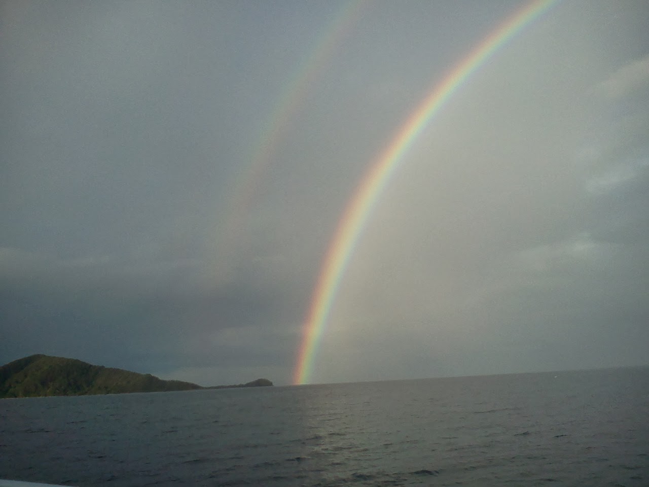
                                          Dawn on 11/5 - Salacia in the rainbow behind us

Wednesday 11/6

Arrived San Pedro, Belize 10am, dropped anchor with our Belize courtesy flag flying and the quarantine flag flying below. When arriving in port the quarantine flag tells the authorities we have not yet cleared in. The Captain goes ashore and meets with the respective officials to complete all the paperwork then back to the boat, the quarantine flag comes down and all is well, and now the crew can disembark.

We waited for Salacia as she was not far behind. Steve radioed the authorities and set up an appointment for 1:00pm to clear in. We readied the dinghy and Charlie picked up Steve and the two of them headed into San Pedro to do the paperwork and pay the fees. We had heard that Belize was expensive so I (Charlie) was apprehensive and on my guard. I really wanted to dive and explore the reefs but cost was a determining factor.

Upon entering the customs office I began my inquiries as to cost. Nothing was posted and I had a vague feeling that  the fees were based on what they could get away with. I let my boat buddy Steve start the process since he was staying in Belize no matter what.  When the immigration officer put Steve’s fee in his wallet, a rather fat wallet at that, and refused to produce a receipt for payment, my alarm bells started ringing. Instead of finishing my check in  - under the guise of needing to go to the bank to get money for  the fees -  I visited the remaining 3 officials to get their charges.
All told, it was going to cost  $50 for immigration, $45 for customs, $40 for Health and $90 for Port Captain plus $5 per day per person payable upon departure from Belize.
For 12 days that totaled another $120. On top of that, if you want to visit any of the National Parks there is a $5 to $10/ per day per person  entrance fee. So the max fee for visiting the reefs could have cost us another $240 making the visit somewhere in the vicinity of $585.00. These fees are all in US dollars.  Since Belize is 2 to 1 the numbers in Belize currency is $1170.00. A sum not to be trifled with on our limited budget. Once the calculations were complete I elected not to enter the country and informed the Port Captain that I would be leaving Belize and continuing on. That’s when things got nasty. The Port Captain, (who quoted my boat buddy a fee $30 below my quote for a boat which was 2 feet shorter), was outraged.
He claimed that since I had landed on Belizian soil I must pay the fee. I explained that if the fees had been published I would not have even bothered to stop in Belize. Furthermore, since I had decided not to clear in and would leave immediately,  I had no obligation to pay any fees. I hadn’t been in harbor for any other purpose than to clear customs and since that wasn’t going to happen I would sail off into the sunset. At that point the Port Captain had me detained and put under armed guard. He was really pissed he wasn’t going to make his monthly income off of me. He made several threatening overtures and spoke with great animation on the phone, in some dialect I didn’t understand, to someone, maybe to no one  - how would I know if he even dialed anyone - but, he made a great show of it. Not wanting to be shipped off to some third world jail or Belize City, I kept my cool and remained seated and calm. At least I hoped I appeared calm. Inside I was boiling. After better than an hour the guard got up and started to leave. Reminding him that his mission was to escort me back to Leap, the office staff responded that that was not his mission, that  indeed he was there to protect the staff from me.  (I really didn’t know I looked that fearsome but I guess standing a foot taller than everyone around me, a false assumption might be made. The Great Viking Warrior! LOL! )
There was some banter around the room regarding my possible criminal behavior of not paying the bribe and it was agreed that I had broken no law. Several calls were placed to the now absent Port Captain and he finally released me, without escort, I might add.  The customs office wished me fair winds and safe passage,  - Like, no hard feelings ok buddy?
Arriving at the dinghy and noting my boat buddy was back on his boat ( he had ridden in with me and back to his boat with the Port Captain) I swung by to say goodbye. The Port Captain apparently was on a boat returning to the dock when he spotted my dingy headed out and proceeded to escort me back to my boat. Now maybe he was happy, he got to be the tough guy after all.

We radioed our cruising buddies on the way out of the reef and set sail in perfect conditions for Utila.

Things were about to change.